GIS Mapping

By using these mapping applications, you agree to the Terms of Use and acknowledge the Disclaimer.
Spatial Viewer
This interactive web mapping application includes zoning and OCP designations, development permit areas, water and wastewater infrastructure, fire hydrants, elevation information, parcel boundaries, high-resolution imagery and more. Users can explore the data, change the basemap, measure, markup, filter and produce prints along with property reports.
Highlights of this system include:
- Multi-year Imagery
- Property reports for all parcels with a folio
- A basemap gallery with over 16 options to choose from
Instructional Videos
Open Data
The Summerland Open Data Hub Site is available for users to view and download the spatial data provided in the Summerland Spatial Viewer in multiple formats, free and on demand as part of Summerland’s Open Government Licence. Datasets available for download include zoning, OCP, development permit areas, electric vehicle charging stations, utility infrastructure, parks, multi-year imagery and more.
Instructional Videos
Navigation & Tools
Navigation
To move around
Left click, hold & drag to pan around
Three methods to zoom in & out
1. Use the scroll on your mouse. You will zoom to the location of your cursor.
2. Use the + button to zoom in and the – button to zoom out. These are in the top left corner of the map
3. Hold the shift key, left click and draw a box on the map. You will zoom to the location in the box.
Splash Screen
Click OK to accept and turn off the splash screen
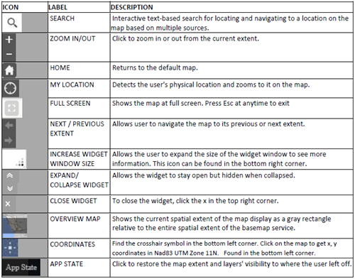
Tools
.png?sfvrsn=d950c7fb_0&MaxWidth=500&MaxHeight=&ScaleUp=false&Quality=High&Method=ResizeFitToAreaArguments&Signature=5444A3286A97D2F3CF758FDDD3F6CD65 "download (1)")
Tip: hover your cursor over the tool and an information box will appear indicating what the tool is.
Acronym List (non-exhaustive)
AGOL: ArcGIS Online.
ALC: Agricultural Land Commission
ALR: Agriculture Land Reserve
DEM: Digital Elevation Model. Both DTM’s and DSM’s are Digital Elevation Models.
DRA: Digital Road Atlas
DPA: Development Permit Area
DSM: Digital Surface Model. Includes surface objects such as plants and structures
DTM: Digital Terrain Model. Representation of the bare earth.
Esri: Environmental Systems Research Institute
EVC: Electrical Vehicle Charging [Stations]
FCL: Flood Construction Level
FWA: Freshwater Atlas
GIS: Geographic Information Systems
GPS: Global Positioning System
CGVD: Canadian Geodetic Vertical Datum. There are two, CGVD28 from 1928 & CGVD2013 from 2013.
ICI: Society- Integrated Cadastral Information Society
LiDAR: Light Detection and Ranging. Remote sensing method that uses lasers to determine the elevation from points on the landscape.
LTSA: Land Titles and Survey Authority. The organization responsible for PMBC
NHC: Northwest Hydraulic Consultants
OBWB: Okanagan Basin Water Board
OCP: Official Community Plan
PID: Parcel Identifier Number
PMBC: ParcelMap BC. Maintained by LTSA and the source of the District’s parcel fabric
[S]ROW: [Statutory] Right of Way
Questions & Inquiries
For any questions about the Open Data site, GIS or mapping at the District or if you encounter an issue with the map that is not addressed in the videos or the user guide, please email gis@summerland.ca.